Search by topic
- archaeology
- Building of Local Interest
- chapel
- charity
- church
- crime
- dressmaker
- fire
- Great Eastern Railway
- Listed building
- Mapping Relief
- medieval
- oral history
- poverty
- Public House
- Religious House
- Roman
- scholar
- school
- Then and Now
- tudor
- women
- work
- world war one
- world war two
Search by text
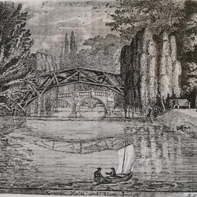
Garret Hostel / Bishop’s Hostel
History of Garret Hostel Lane
Susanna Gregory’s website on the history of Michaelhouse writes:
Besides its core site, Michaelhouse was also endowed a number of houses that it rented out as semi-independent hostels or halls. Still acting as Stanton’s executor, John de Illegh purchased Garrett and Ovyng’s hostels in 1329, at ‘great trouble and expense’, if the Otryngham Book (40ff) is to be believed. These are easy to locate, since they were sited between the enclosed part of St Michael’s Lane to the north and Henney Lane to the south (Otryngham: 44). Henney Lane (named for John Henney, who lived there) is now called Garret Hostel Lane. Both messuages abutted a stream (almost certainly ripa domini Regis) to the west, and a highway (almost certainly Milne Street) to the east. Of the two, Garrett seems to have been the larger and the more important, given that it lent its name to the lane leading to the river, and the area of land between the ripa domini Regis and the river was generally called Garrett Hostel Green. It is possible that the name derived from a ‘gartye’, or a watchtower, suggesting that the building had a high window. It was finally demolished in the 17th century, to be replaced by Bishop’s Hostel (Stamp 1924; Willis and Clark 1988).
The Cambridge City study of the area can be found here:
https://www.cambridge.gov.uk/media/2879/historic-core-appraisal-2016-garret-hostel-lane.pdf
It states:
Garret Hostel Lane lies in the heart of collegiate Cambridge and is evident on maps from the 1570s onwards, probably forming part of the medieval street pattern (formerly as Henney Lane). Garret Hostel stood on the corner of Trinity Lane and Garret Hostel Lane, now the site of Bishop’s Hostel, and was in existence by 1329. An island named ‘Garret Ostell Greene’ lying between two courses of the River Cam appears on Braun’s map of Cambridge of 1574. In 1546 Henry VIII combined the properties of seven hostels (including Garret Hostel) King’s House and Michael House to create his new Trinity College. Braun’s map records the lane as a route from Trinity Lane over a bridge to the island and via a second bridge to the road south to Newnham.
The Railings in Garret Hostel Lane are designated a Building of Local Interest
Projects
Contribute
Do you have any information about the people or places in this article? If so, then please let us know using the Contact page or by emailing capturingcambridge@
Licence
This work is licensed under CC BY-NC-SA 4.0![]()
![]()
![]()
![]()