Search by topic
- archaeology
- Building of Local Interest
- charity
- church
- crime
- dressmaker
- fire
- Great Eastern Railway
- Listed building
- Mapping Relief
- medieval
- oral history
- poverty
- Public House
- Rattee & Kett
- Religious House
- Roman
- scholar
- school
- Then and Now
- tudor
- women
- work
- world war one
- world war two
Search by text
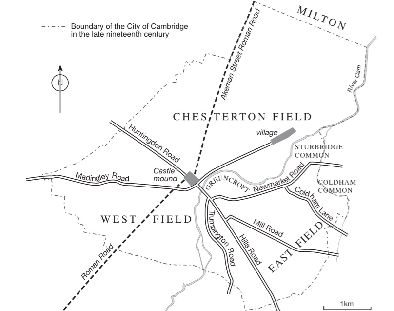
The East Fields of Cambridge
A Reconstruction of the layout of Medieval Cambridge
Of the three large medieval fields of Cambridge borough (West and East Fields, and Chesterton Field), only the West Field has been comprehensively mapped, using early copies of a fourteenth-century terrier. Using other archive terriers, this study completes as far as possible the mapping of the fourteenth-century East Field. Although this Field is now almost entirely built upon, striking correspondences emerge between the patterns of the medieval furlongs and the modern streets. The reconstruction of the fourteenth-century eld pattern shows strip-cultivation extending as far as the waterlogged fenland at its eastern boundary. There is, however, evidence to suggest that arable cultivation in the late eleventh century occupied only about half the fourteenth-century area, with a wide arc of common, pasture and moorland within the eastern and southern boundaries. The possible pre-conquest origins of the open-field system are also discussed.
More Information
- Read the complete article on The East Fields of Cambridge as a PDF
Contribute
Do you have any information about the people or places in this article? If so, then please let us know using the Contact page or by emailing capturingcambridge@
License
This work is licensed under CC BY-NC-SA 4.0


