Search by topic
- archaeology
- Building of Local Interest
- charity
- church
- crime
- dressmaker
- fire
- Great Eastern Railway
- Listed building
- Mapping Relief
- medieval
- oral history
- poverty
- Public House
- Rattee & Kett
- Religious House
- Roman
- scholar
- school
- Then and Now
- tudor
- women
- work
- world war one
- world war two
Search by text
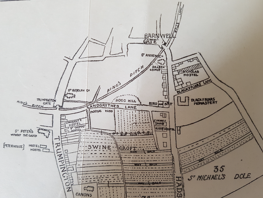 14th century Cambridge map from 'Outside the Barnwell Gate' by H P Stokes, 1915'
Barnwell Gate / Hadstock Road (Via Devana)
History of the Barnwell Gate
In 1267 Henry III was at Cambridge actively fortifying the town during a period of war against the Barons.
Hist. Univ. Camb by T Fuller, ed. Prickett and Wright, pp. 40:
Only the south and east of the town lay open, which the King intended to fortify. In order whereunto he built two gates, Trumpington Gate by St Peter’s Church, now ruined, on the south; Barnwell Gate by St Andrew’s Church now decayed on the east. And because gates without walls are but compliments in matters of strength, he intended to wall the town about, if time permitted him. Meantime he drew a deep ditch (called King’s Ditch at this day) round about the south and east parts of Cambridge. Presently news is brought to him, that Gilbert, earl of Clare, had seized on the chief city of the realm. No policy for the King to keep Cambridge and lose London the while. Thither marched he in all haste with his army, and may be said to carry the walls of Cambridge away with him, the design thereof sinking at his departure.
The Barnwell Memoranda (end of 13th cent.) record how insurgents from the Isle of Ely then came and burnt the gates.
The only actual description of the Barnwell gate come from Dr Caius in 1573 who wrote that there was only one column, one upright wooden post remaining.
Outside the Barnwell Gate (1915) ch. 2, explains the nomenclature of the road that led from the Barnwell Gate south-east:
This road “outside the Barnwell Gate” (now known as St Andrew’s Street, Regent Street and Hills Road) was formerly called by various names: the Hadstock Road, the Friars’ and Preachers’ Street or the Preachers’ Street, the High Street, the King’s Way. “the great street outside Barnwell Gate”; while on later maps it (or the continuation of it) is styled Linton Road, or the road to Colchester, or the road towards the Gog-Magog Hills.
Another name by which this road has been called is the Via Devana. This looks back to Roman times, although the actual title was first applied to it by the Rev C Mason, who was Woodwardian Professor from 1734 to 1762.
This ancient road entered Cambridge on high ground between the fens of Cherry Hinton and Shelford, continued down St Andrew’s street, by Trinity church, to the river to the site of the Roman fort beyond.
In 1688, when a ‘plan of Cambridge’ was drawn by Loggan, there were few houses beyond Emmanuel College on the east side of the road, and the Spinning House on the west side. The neighbourhood of Emmanuel College was long called “the town’s end”.
Beyond this part, all was open country. On the east side (of what is now called regent Street) Parker’s land did not quite run up to the road; nor did St Thomas’s Leys (now called Downing College grounds) run up to the ground on the other side; but there were two strips left of roadside ground which were probably considered waste ground. Some of this is said to have been gradually occupied by squatters, who inclosed patches, or put up buildings which remained undisturbed long enough for them to claim a right of ownership. (History of the County of Cambridge, Edmund Carter, p.19)
Contribute
Do you have any information about the people or places in this article? If so, then please let us know using the Contact page or by emailing capturingcambridge@
License
This work is licensed under CC BY-NC-SA 4.0


