Search by topic
- archaeology
- Building of Local Interest
- charity
- church
- crime
- dressmaker
- fire
- Great Eastern Railway
- Listed building
- Mapping Relief
- medieval
- oral history
- poverty
- Public House
- Rattee & Kett
- Religious House
- Roman
- scholar
- school
- Then and Now
- tudor
- women
- work
- world war one
- world war two
Search by text
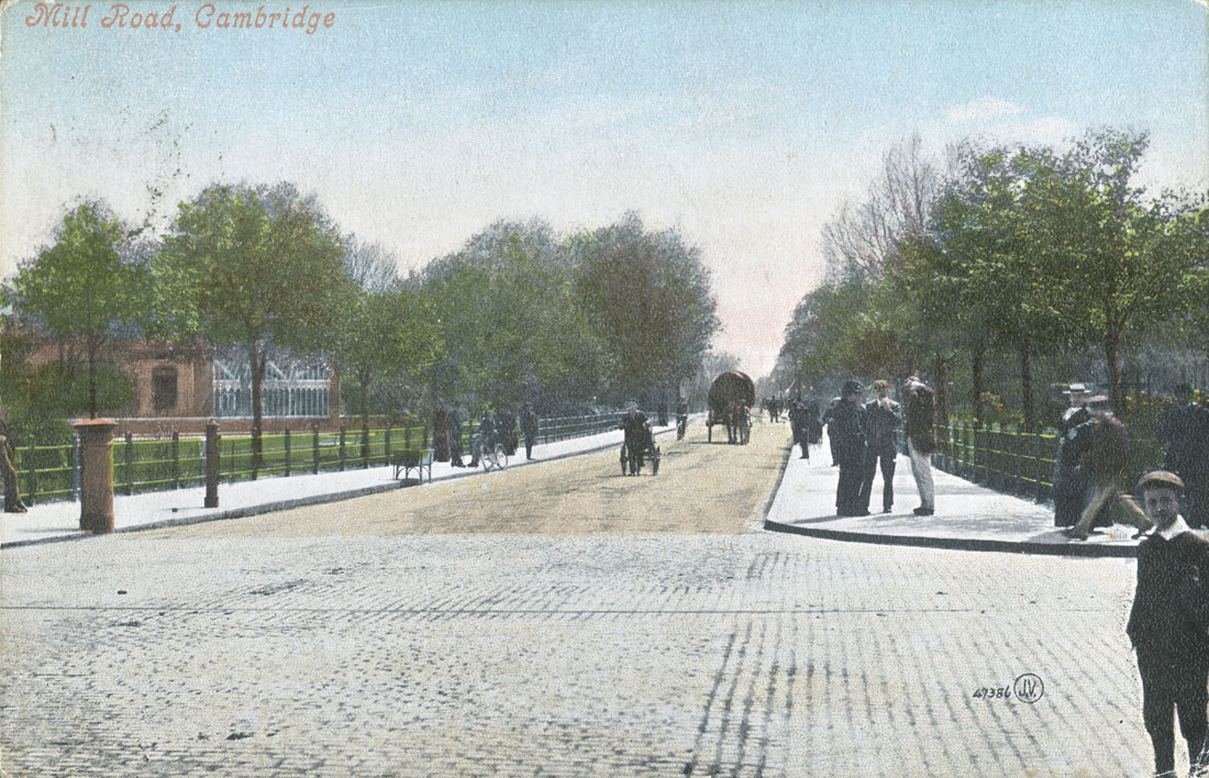
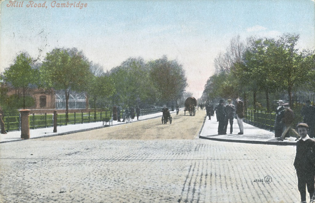 Mill Road © Cambridgeshire Archives
Mill Road 1823-1851
What was here before all the houses?
Mill Road had earlier been known as Hinton Way, a track that ran through the Barnwell or East Field of Cambridge to Cherry Hinton. Together with the West Field and Chesterton Field this was one of three field systems that had surrounded Cambridge since the early medieval period and which had restricted the expansion of the town. In 1800 these fields still confined Cambridge to what in the 21st century has become known as ‛the historic centre.’
Mill Road lay outside the boundaries of the town in the Parish of St Andrew the Less, part of Barnwell, a hamlet clustered around the junction of East Road and Newmarket Road. In the early 19th century the parish had a small population of around two hundred people. By the early 21st century the Petersfield and Romsey Wards had a combined population of 19,000.
Read the complete report (PDF)
Did you know
The first newspaper reference found specifically to ‘Mill Road’ was in 1823, when it was still a private, largely uninhabited road belonging to the adjoining land owners.
John Clack is the earliest identified resident of what would later be known as Mill Road (in 1816).
The first properly developed area of Mill Road was Covent Garden, from 1823.
Mr Humfrey’s Mill, which would give the road its name, was located at 56/56a Mill Road.
The oldest surviving building on Mill Road is either Ditchburn Place or the former Locomotive public house (then known as the British Admiral).
Timeline
1792/1796 – Charles Humfrey’s Mill
1807 – Barnwell Enclosure Act opened up area for development
1815 – first newspaper reference to ‘Mr Humfrey’s Mill’
1816 – first newspaper reference to ‘John Clack at Polecat Close, Barnwell’
1823 – land first advertised for sale on ‘Covent Garden, Mill Road’
1826 – the Chapel of Ease (Barnwell New Church), first institutional building on Mill Road
1829 – new Gaol next to Donkey Common, overlooking Parker’s Piece
1838 – Chapel of Ease demolished
1840 (or earlier) – Swiss Cottage (opposite Union Workhouse)
1844 – Mill demolished and parts auctioned off
1845 – Cambridge railway station built
1846 – The Limes (next to Gothic Cottage)
1847 – Eagle Foundry (site of City Council Depot)
1847 – British Admiral public house renamed the Locomotive
1850 – Gwydir House (site of Gwydir Street and the Bath House)
1851 – Mill Road becomes a public highway
Oldest surviving buildings
1838 – Ditchburn Place (Union Workhouse)
1838 – The Loco (British Admiral/Admiral/Locomotive public house)
1839 (or earlier) – Six Bells, Covent Garden
1848 – Mill Road Cemetery (Parish Burial Ground) Lodge
1851 (or earlier) – Regent language School (Gothic Cottage)
Mill Road in numbers
1830 (from the Baker map)
Mill Road: 4 or 5 houses
Covent Garden: approx. 5 houses
1841 (Census results)
Mill Road: 7 houses, 29 people
Covent Garden: 25 houses, 116 people
1851 (Census results)
Mill Road: 50 houses, 199 people
Covent Garden: 28 houses, 134 people
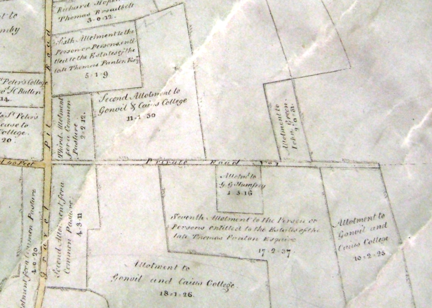
The Barnwell Enclosure Map (1812)
Mill Road is marked on the map as ‛Private Road No 7’.
The approach from Gravel Pit Road (now East Road) is framed by ‛Second Allotment for a Common Pasture’ and ‛Third Allotment for a Common Pasture’. These became Donkey Common and Petersfield.
Progressing down the road, on the right hand side, the ‛Allotment to GG Humfrey’ was the site of Mr Humfey‛s windmill, after whom the road came to be named.
Beyond this allotment, on the opposite side of the road, the ‛Allotment to John Green’ became the site of the Workhouse, now Ditchburn Place.
‛Private Road No 7’ terminates shortly after this, with ‛Footpath No 4’ leading towards Cherry Hinton, just as a descendant of this footpath still leads from Burnside to Cherry Hinton today. No buildings are marked.
Covent Garden
The first significant indication in the newspapers that the area was changing came in March 1823 when the Cambridge Chronicle advertised the forthcoming sale of sixty lots of ‘Freehold Building Land’ in ‘Covent Garden, Mill Road, leading to the footpath to Cherry Hinton’.
Further information
Contribute
Do you have any information about the people or places in this article? If so, then please let us know using the Contact page or by emailing capturingcambridge@
License
This work is licensed under CC BY-NC-SA 4.0


