Search by topic
- archaeology
- Building of Local Interest
- chapel
- charity
- church
- crime
- dressmaker
- fire
- Great Eastern Railway
- Listed building
- Mapping Relief
- medieval
- oral history
- poverty
- Public House
- Religious House
- Roman
- scholar
- school
- Then and Now
- tudor
- women
- work
- world war one
- world war two
Search by text
John O’Gaunt’s House, Bassingbourn
History of John o'Gaunt's House
Listed building on Heritage at Risk Register
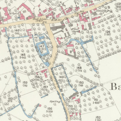
The motte is considered to date to the 12th century when it was one of a group of minor strongholds in the locality. The site was later occupied by a manor house belonging to Warin de Bassingbourn who, in 1266, obtained a licence to crenellate the house with a dyke and stone wall. The association with John o’Gaunt is doubtful, although Bassingbourn market was confirmed to him by Edward III. Part of the moat and some structural features were still visible in the 19th century when the motte stood 4m high. In 1887 some of the stonework was robbed out and material from the motte was used to fill the moat.
John O’Gaunt owned Richmond Manor and his wife Blanche may have died there of the plague. See the following paper:
W M Palmer 1923 Camb Chron. noted the following:
Edward II stayed at the castle in November 1324.
The mother of Oliver Cromwell lived here during the life of her first husband, William Lynn, who died when she was 24.
However the connection to Oliver Cromwell’s mother is not believed to be correct. The Lynnes may have had connections to Fern Cottage in North End.
In 2022 SR sent this email:
My family has a long “connection” with the site having worked for successive owners – the Russell and Howes families from the 1850’s up to 2002. I worked on the area until 1980 when I left the village.
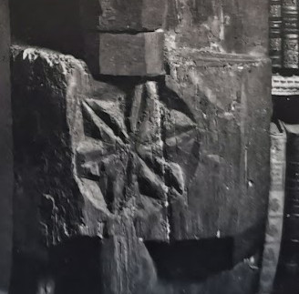
The mound stood until the Great War (1916?) when it was partially levelled, the stonework being removed to repair the roads leading to Dick Sell’s lane. My grandfather William T E Robinson (1901 – 78) worked on the job and recalled walls of clunch 3 to 4 feet high under the mound. This was partially confirmed in the 1980’s when my father William C Robinson (1930 – 2015) was ploughing the site and unearthed a large block of dressed clunch stone some3 feet log by 2 feet wide by 10 inches deep. He removed it from the site: I think it’s still in the garden of 18 South End Bassingbourn where he lived until 2013.
The site itself was never dug for Coprolites unlike the field to the north (18 acres field today).
I remember the last moat being filled in – it was 1963 and this moat was across the field behind the mount running east to west. The causeway moats were filled in 1952 – 1953 using earth from the groundworks of the building of Bassingbourn Village College. The causeway was lined by tall willow trees which were pulled into the moat by traction engine, then some 20 feet wide and very deep, where presumably they remain buried. My dad (WCR) worked on this.
The area was originally several fields known as Halls Close (pronounced ‘ole cluss’ in the dialect); the pastures and 18 acres. It was all laid to meadow until the 1950s and was a haven for wildlife including large grass snakes. Peter Sell of the Botanic Gardens (a contemporary and friend of our family) listed the plants and wildlife: there was an unusual hazelnut on site which Sell speculates could have been on site since Roman times.
It’s often claimed the the causeway extended to the church. My own work suggests that this is unlikely — there are ground signs across the road in the field known The Fillance (medieval ‘Kyllands’ – dialect corruption) and WTER said that horse ploughing the Fillance was always harder in the area just inside the boundary closest to the castle.
If you take a line from the causeway, a straight line leads to the Bury Yard – opposite the church and the site of Richmonds Manor. If – and it’s a big if – there was an extension, did this link the two major manors of the village along an access? There’s no doubt that the whole landscape north of the Litlington Road has been extensively altered probably to a plan to control water and the mills. River’s aren’t that straight in real life.
One last thought. The Fillance is a large area surrounded by a bank. Its original shape is identical to a Roman Fort. Is this the original area of settlement? Bear in mind a Roman figurine of Diana was found somewhere in the vicinity in the 19th century. I have in my possession a polished Neolithic hand axe, also found in the area in the 1950s so is this an earlier site? Lots of questions.
Contribute
Do you have any information about the people or places in this article? If so, then please let us know using the Contact page or by emailing capturingcambridge@
Licence
This work is licensed under CC BY-NC-SA 4.0


