Search by topic
- archaeology
- architecture
- bricklayer
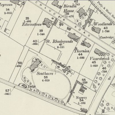
- Building of Local Interest
- carpenter
- church
- crime
- dressmaker
- fire
- Great Eastern Railway
- listed building
- medieval
- oral history
- Public House
- Rattee & Kett
- Religious House
- Roman
- scholar
- school
- Then and Now
- tudor
- women
- work
- world war one
- world war two
Search by text
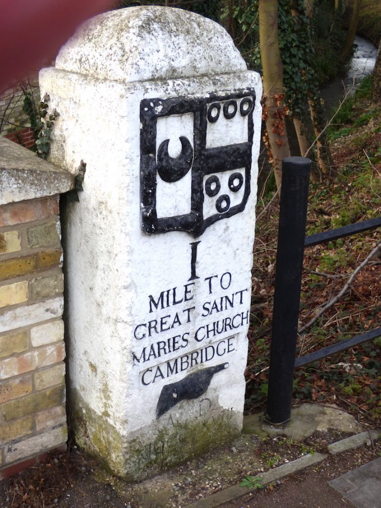 Milestone near Chaucer Road.
Photo: Andrew Roberts
Milestone near Chaucer Road.
Photo: Andrew RobertsEarly milestones: Cambridge to Barkway
Early milestones
Milestones were erected in 1728 along the Fowlmere to Cambridge Turnpike Road. The first milestone from Cambridge (shown) is at the Stone Bridge (now the junction of Trumpington Road and Brooklands Avenue). The second milestone is on Trumpington High Street near Wingate Way. The third milestone is on Hauxton Road near the entrance to the Park & Ride site.
Notes on Trinity Hall Milestones by Ken Fletcher
The modern town planner is often concerned with the design of what has become known as street furniture, but here in Trumpington we have examples of some of the oldest street furniture in England. The three milestones, at Brooklands Avenue, at Wingate Way, and in the Hauxton Road were erected in the early 18th century and are reputedly the first milestones erected in England since those of Roman times.
The three milestones in Trumpington are part of a line of sixteen which run from Cambridge to Barkway in Hertfordshire. All sixteen are standing today and have an interesting history.
The milestones have their origin in the generosity of Dr William Mowse who was Master of Trinity Hall from 1552 until 1559. When Dr Mowse died in 1588 he left the residue of his estate, some £1,000, to the College and this, together with a gift of £600 from his executor Robert Hare, was used to purchase an estate in 1597. This estate, at Walpole St Peters in Norfolk, was held in trust with the income to be used for repairing he roads around Cambridge and especially to Barkway.
This would seem to us to be an unusual request, but medieval England’s roads were appallingly bad and most long distance traffic went by boat on rivers or along the coast. Many wills of the time left bequests or he repair of roads. In the Vision of Piers Plowman, written in the 14th century, rich merchants are urged to support the repair of roads and bridges as well as more usual charities.
In 1555 a Act was passed requiring parishes to keep their local roads in repair. The parishes appointed a local surveyor who then claimed labour from local residents. This system was notoriously in effective as parishes had little interest in maintaining roads for travellers. The unpaid surveyors were appointed for one year only and so had little opportunity to build up experience and were generally reluctant to serve, and local residents were even more reluctant to provide free labour to repair the roads. Parishes could be charged before the Justices for neglect of their duty, but roads were still in a poor state of repair.
Parishes with main roads running through them were particularly badly served by the 1555 Act. The cost or repairing the road, which was mainly used by travellers, had to be borne by local inhabitants. This was a particular problem for those parishes on the Great North Road, both the old road which is now the A1, and the new road via Royston and Huntingdon and joining the old road at Alconbury. During the early 17th century there were various attempt to devise ways of getting travellers to contribute to the repair of the roads. Finally in 1663 a turnpike trust was was established for road from Wadesmill in Hertfordshire to Stilton and was prompted by the small parish of Standon which bore the responsibility for maintaining the Great North Road and was regularly before the Justices because of failures to repair the road.
The Turnpike Trust approach gradually gained favour and many trust were established during a “Turnpike Mania” in the 1750s. One of the earliest trusts was for the road from Trumpington to Foulmire (Fowlmere) (11 Geo.1 c.14). The college trust was thus relieved, in part, of the need to maintain the road condition and so funds became available for the erection of the milestones.
Very much detail on the Walpole Trust and the erection of the milestones was recorded by William Warren, a 18th century fellow of Trinity Hall responsible for he trust. This record “Warren’s Book” was published in 1911 and is the main source for the early history of the milestones.
The milestones were erected over a period of seven years from 1725 until 1732. This was an extended period because only two days a year were devoted to the erection. For the years 1725,1726 and 1727, a day was spent measuring a length of five miles and then in the year milestones were erected. Initially small markers were set up, but those at 5, 10 and 15 miles larger than the others.
These large milestones are those we see today with the arms of Trinity Hall, the mileage to Cambridge, a pointing hand and a date . In subsequent years smaller stones were replaced by larger stones and finally a marker was erected on Great St Mary’s church
Dr Warren, with two men Henry Bridges and Thomas Milton, measured the distances using a 66 foot chain and the stones were prepared by a mason, John Woodward. Typically the cost of making the measurements was 3 shillings and the larger milestones, in Portland stone, cost three pound each although there was some variation in cost.
The detailed timescale was:-
1725
2nd July, First 5 miles measured
20th October, 4 small stones and large stone at 5 miles erected.
1726
29th April, Further 5 miles measured
25th June: 4 small stones and large stone at 10 miles plus “a stone directing the road to Royston” erected.
This extra stone was on what is now the A505.
1727
2nd May, Final 6 miles measured
20th October, 4 small stones and large stone at 15 miles erected.
The milestones having been established the replacement of the small markers with large stones was commenced.
1728
25th April, Erection of large stone at 1 mile to commemorate the visit of George II to the University.
29th May, Large stone at 16 miles erected at Barkway
These two stones have the arms of Dr Mowse (at 1 mile) and Robert Hare (16 miles) added to those of the college.
1729
6th May, Large stones at 2 and 3 miles erected.
29th May, Large stone at 4 miles erected.
1730
29th May, Large stones at 6, 7, 8, and 9 miles erected
1731
25th August, Large stones at 11 and 12 miles erected.
1732
4th October, Large stones 13 and 14 miles erected.
19th October, Circular marker set in buttress of Great St Mary’s.
“Warren’s Book” shows the detailed accounts for the erection of the milestones from which the following expenditure can be established.
1725 Payment for measurement was 3/- and £2.12.0d for the large 5 milestone and four small ones. This charge includes erection.
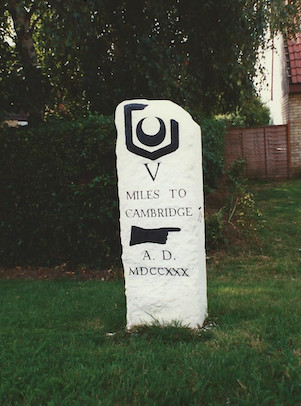
Cambridge to Barkway, milestone V
1726 Payment for measurement was 3/- and £3.3.0d for the large 10 milestone and four small ones
1727Payment for measurement was 5/- and £3.10.0d for the large 15 milestone and four small ones.
Prices were stable at this time so the increased costs assumedly reflect the increasing distance from Cambridge.
1728The first milestone cost £5.8.0d and the 16th £6.0.0d. These two stones have more complex carving and are also larger, 8ft and 7ft overall respectively, than the other stones which are 6ft or less. Originally this cost was charged to the trust, but subsequently Dr Warren paid for these two stones.
1729 The stone for the second and third milestones cost £12.18.6d.
1730 The four stones for the 6, 7, 8 & 9 miles cost a total of £12.2.0d
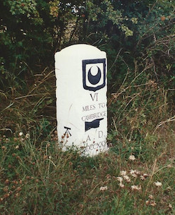
Cambridge to Barkway, milestone VI

Cambridge to Barkway, milestone VII

Cambridge to Barkway, milestone VIII
1731 The two stones for the 11th and 12th miles cost together £12. The 11th stone has some additional carving because it stands at a crossroads and again the distance from Cambridge is greater.
The final two stones at 13 & 14 miles cost £16.18.0d.
The book does not show the cost of the disk at Great St Mary’s.
Thus the total cost of erecting the milestones, spent over a period of eight years, was £52.1.0d or in modern terms £52.05.
The milestones have survived perhaps because the Trumpington to Barkway road is now a minor road and has not suffered major widening or improvements. It is crossed by the M11 but the large roundabout is between the 3 & 4 milestones and so they were unaffected by the change.
The stones have, however, been affected by the years. The level of the road surface has risen and on some of the stones the lower carving of the date has been obscured. This is especially true of the 15 milestone which has been almost totally covered as the level of the road has changed. The sequence of the milestones from 12 to 16 have been modified by the addition of a cast iron plate which shows the mileage to London, Barkway and London. On all but the sixteenth this has been mounted where the college arms are carved, but on the sixteenth the plate sits below the arms. This plate has been fixed on all the milestones outside of Cambridgeshire. The plate is also fixed to the 12th milestone which is now n Cambridgeshire, but only since the boundary changes of 1895 . This suggests that the plates were fitted by a Hertfordshire local authority late in the nineteenth century and this is confirmed by the style of the plates which is Victorian.
During the second world war “an sign which furnished any indication of the name or direction to any place” was removed. A recent history of Trinity Hall explains that “in 1940 the roadman sensibly laid these heavy stones flat and buried them under the grass verge: they were re-erected in 1946, undamaged except that one had disappeared during work at an airfield. The airfield mentioned is most likely to be at Fowlmere, but the stone here appears to be original. Either one is a very good reproduction or the original stone was found. It also appears that at least two of the stones near Cambridge were left standing. One local history suggests that the word “Cambridge” was removed from the first stone at the beginning of the war. Certainly on this and the third stone the word “Cambridge” is inset as it would be if the word had been removed and then re-carved at the end of the war.
This series of milestones is an interesting survival from the early eighteenth and form a fascinating reminder of the history of the area. The inscription on the disk at Great St Mary’s makes the claim that these are “the first true milestones in Britain since Roman times.” Certainly no authority existed before the early 18h century who would have set up mileage markers, and when Thomas Telford was designing milestones for the Holyhead Road (built 1815-1840) he complained he could not find a milestone to copy – perhaps he should have come to Trumpington!
Contribute
Do you have any information about the people or places in this article? If so, then please let us know using the Contact page or by emailing capturingcambridge@
License
This work is licensed under CC BY-NC-SA 4.0![]()
![]()
![]()
![]()