Search by topic
- archaeology
- Building of Local Interest
- chapel
- charity
- church
- crime
- dressmaker
- fire
- Great Eastern Railway
- Listed building
- Mapping Relief
- medieval
- oral history
- poverty
- Public House
- Religious House
- Roman
- scholar
- school
- Then and Now
- tudor
- women
- work
- world war one
- world war two
Search by text
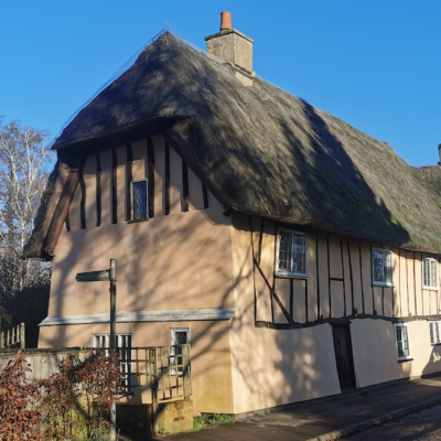
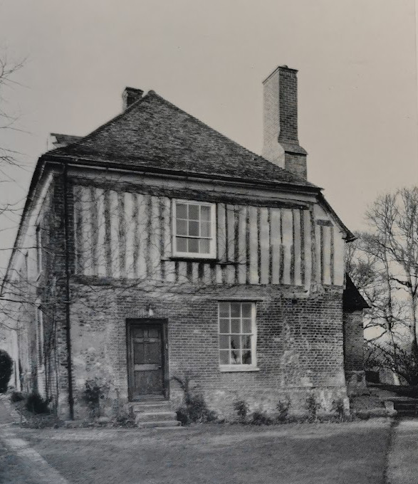 Kingston, Wood Farm, early 16th cent. (RCHM)
Cambridgeshire in the 16th century
Cambridgeshire in the 16th century
This is an edited AI generated summary of the evidence available on Capturing Cambridge for events and developments in Cambridgeshire during the 16th century. As such it will be periodically updated and checked as new material is uploaded. Comments are welcome.
The 16th Century in Cambridgeshire: A Detailed Historical Study Through Capturing Cambridge
The 16th century was a transformative era for Cambridgeshire. The period — overlapping with the Tudor dynasty, the Reformation, the growth of Cambridge University, and major economic changes — left a distinct and enduring imprint on the county’s buildings, landscape, governance, and social life. Using the evidence preserved in Capturing Cambridge, a community-driven digital heritage project, we can reconstruct a richly textured picture of Cambridgeshire during this pivotal century. While the site contains materials from many periods, a surprising number of entries, maps, and building histories provide direct insight into the 1500s or relate closely to developments in that century.
This study brings together these fragments — including building histories, archaeological summaries, religious sites, and land-use evidence — to create a comprehensive narrative of Cambridgeshire in the 16th century.
I. Context: Why the 16th Century Matters in Cambridgeshire History
The century spanning 1500–1600 was marked by:
1. The Reformation and the Dissolution of the Monasteries (1536–1541)
2. Growth and consolidation of Cambridge University
3. Early urban development and the first modern town layout
4. Agricultural and rural restructuring
II. Case Studies From Capturing Cambridge (16th-Century Evidence)
A. Urban Buildings and Domestic Life
1. 15–16 Bridge Street (early 16th century) — Surviving Tudor domestic architecture
These timber-framed houses represent one of Cambridge’s clearest surviving architectural links to the 1500s. They show mixed-use living patterns, with businesses at ground level and domestic quarters above.
2. The White Horse Inn, 2 Castle Street — A 16th-century hostelry
Parts of this inn date from the 16th century. Its location on the northern approach to Cambridge illustrates the importance of road-based trade and travel.
3. Hobson’s House, St Andrew’s Street (late 16th century)
This building, later associated with Thomas Hobson, reflects late Tudor merchant wealth and the growing importance of horse transport for the university.
B. Milling, Waterways, and the Economy
4. King’s Mill & Bishop’s Mill — milling economy in the early 1500s
A 1507 lease and the 1574 Lyne map attest to the economic importance of Cambridge’s mills. They were critical in sustaining both the university and the town.
C. Religious Houses: Dissolution and Aftermath
5. Austin Friary — a major 16th-century turning point
The friary’s suppression in 1538 reshaped Downing Street. The land passed first to private owners and later to university use.
After dissolution, its lands were repurposed, revealing the profound change in land ownership and urban expansion patterns.
D. University Expansion and Town–Gown Relations
The century saw key settlements in the conflict between townspeople and scholars. University authority strengthened under royal favour.
8. Emmanuel College (1584)
Founded on the site of the Dominican Friary, it symbolises the transformation from monastic to academic power.
E. Rural Cambridgeshire and Land-Use Change
9. Croxton deserted medieval village & 16th-century garden
This important site reflects rural depopulation and the transformation of manorial landscapes.
10. Fen-edge settlements
Entries from villages such as Waterbeach show continuity in fenland livelihoods: grazing, peat, fishing, and seasonal movement.
F. Trade, Roads, and Inns
11. Bridge Street and Magdalene Bridge
Already a major artery by 1500, with surviving Tudor houses proving long-term continuity of commercial activity.
12. Trumpington Road
A key southern approach lined by inns, showing early modern transport patterns.
13. Market Hill
The commercial centre of Cambridge, with building plots that stabilised in the 1500s.
G. Social and Cultural Life
14. Taverns and hostels
Sites such as the Falcon Inn illustrate the central role of public houses in Tudor social life.
15. Early printing
The reuse of the Austin Friary as a printing site shows Cambridge’s emerging role in Protestant scholarship.
H. Mapping and Spatial History
16. Lyne’s 1574 map
Referenced in several Capturing Cambridge entries, this map is crucial for reconstructing Tudor Cambridge.
17. Parish boundaries
These structures shaped taxation, charity, schooling, and local governance.
III. Themes Emerging from the Evidence
1. Transition from medieval to early modern
2. Dramatic change in property ownership after dissolution
3. Rise of colleges as dominant landowners
4. Contrasting rural fortunes
5. Continuity of streetscapes and domestic structures
IV. Conclusion
Capturing Cambridge preserves invaluable evidence for understanding the 16th century. Through buildings, sites, maps, and landscape traces, it allows a reconstruction of one of Cambridgeshire’s most formative centuries.
Projects
Contribute
Do you have any information about the people or places in this article? If so, then please let us know using the Contact page or by emailing capturingcambridge@
Licence
This work is licensed under CC BY-NC-SA 4.0![]()
![]()
![]()
![]()